|
Many thanks for permission to use graphics from their software and toposheets |
|
|
23 February 2007 A Step UpThe Greenstone TrackDay 2, Page 5 Steele Creek. This is where Carol and Mike will be emerging in a couple of days time. 8-10 hours. Hmmmm. I imagine that's as far as the Upper Caples hut. Carol and Mike were planning to camp about half-way along.
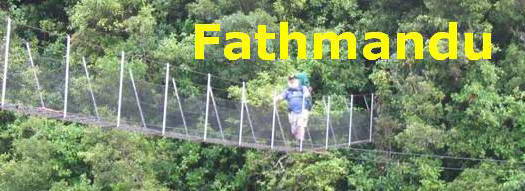
I have since been told that DoC times are adjusted according to the general fitness of people they believe will commonly be using a given track. Unfortunately, we are not privy to the mathematical formulae used to calculate these adjustments. Like Will Rogers, all we know is what we read on the signs. And here's the Steele Creek suspension bridge. Not the longest I have ever been over - that's still probably the Heaphy bridge - but definitely, and by a considerable margin the highest so far. The design is one I have now come to recognise and trust. Fortunately. I point my eyes to the hills from whence cometh my help, and count my way across. A quick peek reveals the tops of trees somewhere down below.
For a brief spell, I am leader of the pack. Miranda stops by Steele Creek downstream from the bridge to get some photos. You can just see her coming across the valley.
I am getting increasingly tired and hot. The sun is uncompromising and there is no shade to be had except that provided by my hat.
I reach the top of the ridge and wait for her. Standing still gets me even hotter, and crosser, though, being polite - and stupid - I say nothing. She takes better photos than I do. She has a right to stop and take her time to get the quality she wants. There are few things more cancerous than virtuous long-suffering. We head down towards the river.
We disturb a calf feeding from its mum. Out here, calves are not separated from their mothers early on as they were in the dairy farms I grew up on. It's a nice picture though I am sorry about our inadvertent interruption. We move past as quietly as possible
Across the river, the terraces are clearly visible. I make a resolution to obtain a copy of Charles Cotton's classic Geomorphology of New Zealand and read it thoroughly before I come down next.
Up ahead the valley moves around to the left
We find ourselves down beside the river. Miranda tells me she's going to grab a splash bath in the shallows to take out some of the heat, but I am tired and I don't hear this, and I think she is simply going to get some photos of a paradise duck.
I carry on, pausing in the heat from time to time to see whether she has finished taking photos. Not a sign. I am grumpy as hell by now and, despite plenty to drink, almost as hot, and I head on mumbling imprecations and full of self-pity about differential surface volume ratios. I am about 500m ahead by this time and it is a good half an hour later before she catches up. The path winds around the edge of the river
and out onto the flats again
Now there's an imposing piece of beef. These fellows show no sign, fortunately, of the aggression common to the Jersey bulls I knew as a kid. He just looks up as I walk past a few metres away, and then returns to grazing.
|
|


